Ettina Bhuja is located deep within the Western Ghats, famed for its dense rainforest and wild wildlife, in Shishila, Karnataka, India, around 15 kilometers from Dharmasthala. This location was named from the appearance it makes when viewed from a distance. It looks exactly like an ox’s shoulder (Ettu – Ox, Bhuja – Sholder). Yes, Ettina Bhuja is an ox’s shoulder. Ettina Bhuja is flanked by numerous other peaks, including Amedikallu.
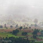
Ettina Bhuja hike starting point

We began our journey at Anu Gowda’s place. You can go to this location via bus, and their residence is the final stop. To get to their residence, there is a well-maintained asphalt road. We arrived here early in the morning. The climb is well-known in this area, and most of the divers can readily direct you to the Ettina Bhuja starting point.
Crossing the stream
We began our trip after breakfast, passing through their farms and over a river. Because the water level is not very high, you can easily cross this river without getting your shoes wet. This may not be the case during the monsoon season. Soon after crossing the river, there is a temple where you can pray for a safe journey.

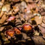
Wildlife along the hiking trail
We continued for another 30 minutes until we came to a brook on the right, which was the last place we found water. Be cautious in this area because it is notorious for its wild elephants. We could clearly notice this due to the recent loss of trees and their manure. Villagers/Guides informed us that there were 12 elephants and a calf nearby, which might be deadly if an attack occurs.
We continued on, and the entire walking track from Anu Gowda’s residence to the mountain is around 8 kilometers long. It takes about four hours to reach the summit. Two-thirds of the hike is in dense forest where you may stroll in the shade, but it is steep in some spots. There is a strong ascent just before reaching the summit.
The summit climb to Ettina Bhuja

Climbing the hill to the finish line is virtually steep and dangerous. You’ll have to get down and move a little if you want to rest beneath a tree. Climbing from three sides is quite impossible unless you are a rock climber. However, the backside, which is not visible from afar, is a steady ascent to the top, with just the last section being a tight ascent. It’s more akin to climbing a tree. There isn’t enough area on top to camp, but there is plenty for great Instagram photographs. Even in the summer, there is an ice-cold stream just before the peak, which you can confirm with the locals.

Dakshina Kannada is on one side of the summit, while Shimoga is on the other. There is another method to reach the mountain, and on the way, there is an ancient temple that may be seen from the top. Many people use this as an escape route. It will be a shorter walk, only around 4 kilometers long, and there will be a jeep track. Because of the extreme warmth and humidity, trekking to this location during the summer might be difficult for first-timers. Be cautious and do not linger in the forest for an extended period of time.
Relaxing after the hike

We returned to our starting location and spent the evening beside the river. We had an early dinner and spent time around the campfire before catching the local public night bus back to the city. If you are willing to spend two nights traveling to and from Bangalore, you may easily accomplish the hike in a day.
Ettina Bhuja YouTube video
Hope you enjoyed reading this blog post. Buy me a coffee to support my work or you can go to my store to buy some of my images. Also, do not forget to join my FriendZone by signing up for my newsletter. Consider subscribing to my YouTube channel.